Meeting
the Mountains
Laurel Peña
I don't
remember what made me agree to give that friend a ride. I
didn't even know her very well But one day five years ago I visually
followed the numbered highways on a AAA road map. 101 to 299 to 96. I saw
the lines of rivers drawn against the light green that meant National
Forest. Back then I thought I knew what to expect. East side of the Coast
Range, ghost pines and firs, lots of chaparral. It seemed north enough for
redwoods to be growing near water. I expected creeks like the ones I knew
from growing up in Sonoma County, flowing in the winter and disappearing
in the dry summer, leaving a silty path through willows for a thirsty
hiker to walk.
I didn't know then how much
ordinary maps hide from the mind. There are better maps, I know that now.
If I had looked at a geology map I would have seen arcs of color denoting
bands of different rock. The thin lines curve around to the west, cozying
up to the Coast Range but separate from it, much more colorful --meaning
more diverse. A vegetation map would have been a crazy quilt of color. Its
patterns follow the geology just slightly, seeming to respond more to
elevation, rainfall, and chaos theory.
Even an old unreliable Forest
Service map would have given me the names of the creeks and mountains --
like I-Am-Up Ridge and Jackass Creek -- telling me that something
different was in these hills. As it was, I just went by the numbers. 101
went through familiar forests to Arcata. 299 climbed east from there past
brutal clear cuts (Simpson Timber Company land). Still nothing unexpected.
Past a low mountain called Berry Summit things began to change. The usual
Coast Range forest response to being inland is to crouch down, become
chaparral, send an occasional sun beat tree up like how a Hollywood cowboy
under siege carefully raises his hat to test the air for bullets.
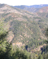
Twenty miles inland now, and I
should have been seeing that. But this forest was standing tall. Defiant.
Instead of changing habits it had changed species to pines, Doug firs, and
cedars which could take the heat and thrive. The mountains looming behind
them were changing too. It’s hard to define how. They seem sharper
outlined and more solid than the Coast Range. Right about there, before
you hit Willow Creek on 299, you leave the Coast Range and enter a whole
new place. The Siskiyou Mountains. I could see it, that first time, but I
didn't have the words for it. So I rode in silence watching the change.
Every time since I have looked for the place, something like a crack in
the stone road cut, where the mountain ranges meet. But it's a gradual
change, and has as much to do with spirit as with stone.
At Willow Creek we turned
north up Highway 96. It’s easy to miss the turn, which makes the road
seem like a secret entrance. Past this gateway your view opens up a little
and you can see the mountains in their real form, as long, pyramidal
ridges one hiding another hiding more. I now know that the ridges at 2,000
feet or so are just the foothills of taller mountains that keep their snow
into the summer, that almost but not quite break tree line. Instead they
shelter diverse groves (10 species of conifer trees together is not
unusual) with relict species that have hidden there from the glaciers and
climate change of the last 10,000 years.
And the water. the mountains
support year round flows of clear, cold water. Hundreds of these creeks
pour down into the Klamath River, Salmon River, Trinity, Scott, Illinois,
or Rouge Rivers. The healthiest salmon runs left in California follow
their pathway in reverse, from the ocean, up the rivers, to spawning beds
in the shallows of the creeks. On that first visit, I learned that most of
the water was safe to drink, in a sense. The small creeks high up were
usually free of the kinds of bugs and critters that get you sick. But
there's a long standing superstition that drinking the water of the these
tributaries will bind you to the land forever, and keep you always coming
back to it. I went to the water’s edge one day, dunked my cupped hands
in, and deliberately drank it down. Five years later - years of being
unable to hold a steady job, develop a steady relationship, or grow a
garden through from planting to harvest, always pulled to be back here - I
still don’t regret it.
Laurel first came to the rivers in 1997, living near Happy Camp. She currently lives in Montana and is homesick for the river.