|
A Talking
History of the Salmon River
The Salmon River Watershed is unique.
Unlike the other major tributaries of the Klamath River, the
Shasta, the Scott and the Trinity, the Salmon does not run through a
valley on it’s journeys. It
has no farming, industry or major population within it’s
boundaries, keeping it one of the cleanest rivers in the west.
The North Fork of the Salmon has it’s headwaters in the
interior of the Marble Mountains Wilderness and the Russian
Wilderness. The South
Fork of the Salmon drains the Salmon Mountain Wilderness and the
divide of the Trinity Mountain Wilderness.
The whole course of the watershed is steep and rugged.
The Salmon River is a wild, free flowing river.
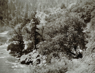
South Fork of the Salmon River, above Indian
Creek 1890
courtesy of Bill Balfrey
note rocks at river level, river right |
Indian
tribes in the mid Klamath River area were often small, largely
familial villages. Though
tribal languages were different, and are traced to different
roots, they shared spiritual and ceremonial ties, trading with
neighboring villages in a mutual interdependency.
The Karuk have inhabited some river areas for ten
thousand years.
The first
white men to see the areas east and west of the Salmon River
were hunters and trappers of the Hudson Bay Co. that passed
through the Scott Valley in the 1820's and a small troupe of
trappers, led by Jedidiah Smith, passed through the Hoopa
Valley around the same time, looking for a way out of the
Spanish held lands of California and into Oregon Territory.
He
had come inland after finding progress up the coast to be time
consuming due to the effort of trail blazing around the fallen
redwood giants. Smith got no further by the inland route,
being blocked by the Siskiyou Mountains, and returned to the
coast and the journey north to Oregon. |
The early white men found spring and fall runs of salmon in the
hundreds of thousands, blacktail deer, mule deer, elk, antelope
black bear, grizzly bear and mountain lions in abundance.
Gold brought the white man into the country permanently and
the Salmon River was subsequently
“discovered” in 1850.
Soon Sawyers Bar had a couple thousand residents and numerous
mining related townships dotted the watershed.
At first the trails into the Salmon River were long
established game trails. Many
of the miners arriving from ships on the coast came into the Salmon
River along the trail running the ridge of the Salmon Mountains,
going up to the ridge at Butler Flat and continuing past Cecilville,
on the upper South Fork. The
trails dropped down the major creek drainages to the miners’ sites
in the narrow river valley. In
the 1860 presidential election the official polling place was at
Election Camp, on the 6000 foot ridge just south of Mary Blaine
mountain. Mary was said to have run a house of ill repute up on the
beautiful peak. One
story has Potato Mountain just to the north, getting it’s name
from the food stores (mostly potatoes) that had to be dumped to save
the pack animals when an early snowstorm forced the pack train to
turn around before making it’s destination.
It wasn’t until 1892 that a road was punched through the
wilderness over Etna Summit to connect the two towns of Etna and
Forks of Salmon. The road from Forks to Somes Bar, along the river, wasn’t
completed until 1925. Mules
and oxen were used to haul in everything the miners needed for their
far flung operations. Old
timers tell of driving the first Model T’s over the steep
switchbacks on Etna Summit in reverse, as it was the strongest gear.
A supply coach (truck) used to make the weekly trip from
Yreka to Sawyers Bar, to Black Bear Ranch, to the King Solomon Mine
and back out again in three days.
The Eddy Gulch Mine, Black Bear Mine, White Bear Mine, King
Solomon Mine and countless others, took millions of dollars of $12
to $16 an ounce gold out of the Salmon River area in the 1850's
through the 1890's. The
owner of the Black Bear Mine, John Daggett. was California’s first
Lieutenant Governor and a good Knownothing Party member to boot, as
were many of the original state government.
His daughter, Hallie Daggett, was the first woman fire
lookout. She was
stationed on Blue Ridge Mountain and had an apple orchard at Blue
Ridge Ranch that still produces today.
Folks on the Salmon River, back then, as now, made their
living in a variety of ways. Combining
a mix of logging,
mining, fire fighting, fishing, packing, hunting, gardening and
gathering allowed people to make a decent, if rugged, life for
themselves. Making it
through a winter has always been the test of a newcomer.
|
The late 1960's brought a new population surge.
Newcomers settled into old mining claims and patented
lands, providing a stable, diverse community mix.
The 1970's and 80's saw school populations rise and
river communities experienced a cultural revival.
In the late 1970's local citizens groups stopped the
Forest Service’s use of herbicides in the watershed.
Isolation,
impenetrability and distance from mills and markets kept
commercial logging quiet until the 1960's when more easily
accessible timber had been logged out.
Until the late 1970's logging was seasonal work and
came to a complete halt when the “snow flew”.
After the Hog Fire in 1977 the pace of logging
accelerated and by the 1990's the Salmon River watershed had
suffered significant environmental impact, to both the quality
and diversity of forest and river habitat.
After the Complex Fires in 1987 the Forest Service
evicted miners from their small family claims.
The Forks Store burned. The river population plummeted.
2001 saw the closing of the Sawyers Bar School and
it’s merging with the Forks of Salmon School District.
The Salmon River has always been a destination for deer
and bear hunters, salmon and steelhead fishermen.
It was in the early 1980's that the boom in river
recreation brought commercial operations into the Salmon River
Watershed. |
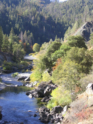
South Fork of the Salmon River above Indian Creek
today
note rocks at river level, river right |
The Salmon River Restoration Council, a community based
non-profit organization, was established in 1993.
Their mission has been to protect and restore the Salmon
River ecosystem, promote the diversification of the local economic
base and promote cooperation and communication between resource
managing agencies and resident community members.
The 751 square mile Salmon River Watershed is currently
inhabited by an estimated 300 people.
98.7% of the land is in federal ownership, with 1.3% in
private hands. 67% of
the Salmon River Watershed is in the Karuk Tribe’s ancestral
lands.
Return to Index
Back to Top
|